Approximate Route |
November 2nd, 2002 ~7.5 miles RT 4100 vertical feet |
|
Approximate Route |
November 2nd, 2002 ~7.5 miles RT 4100 vertical feet |
This was a Stanford Outing Club trip led by Peter McColgan.
Although, most of the group left on Friday night and camped at Wrights Lake, I decided to leave very early on Saturday morning and meet the group at the trailhead. I left with Mark at 6am and after a 3.5 hour drive from the Bay Area, our first task was to find the trailhead.
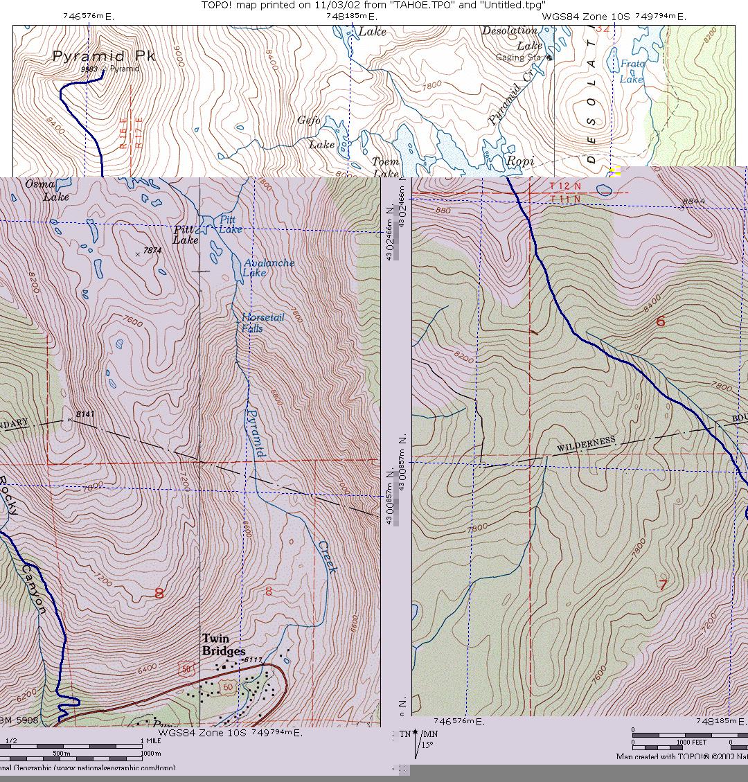
The use trail starts 150 yards Northeast of the turnout. It's not next to the creek! The trailhead is just next to the rectangular black and white sign marking mile 59.0 of HW 50. Also, somebody sprayed painted a green "T" on a rock next to the place where the trail starts. This is a good use trail (although very steep), so if you find yourself bushwhacking, you are not on the trail.

After 2000ft, the trail leaves this small ridge, becomes less steep and eventually crosses to the West side of Rocky Canyon. The "use" trail is extremely good and it is easy to follow (assuming you were able to start on it). There is not bushwhacking as long as you stay on the trail. If you are bushwhacking, you are not on the trail, go back and try to find where the trail went. There are even reflective markers and metal arrows attached high on trees in easy-to-miss spots (these markers are high as they are intedend for cross country skiers).

After 3600 feet of easy Class 1 hiking, then the interesting part starts. The last 400 feet are an easy Class 2 boulder field. If you choose your route wisely (stick to the left as much as possible), the boulders are not very big and most people shouldn't have any problems with it. Also, the higher you go, the gentler the slope becomes (however, that also means that the summit "seems" to get farther and farther).

We got to the top of Pyramid around 2:15pm. There was an incredible view from the summit, although it was very hazy towards the South due to a forest fire. Aloha Lake looked very strange (and quite dry) from above. We were also able to recognize the major peaks in the area: Tallac, Dicks, Mount Price, Roundtop, and the sisters. Sierra-at-Tahoe and Heavenly ski resort were easy to spot. There was "some" snow visible on the runs, but given that the North Face of Pyramid was almost snow free (except for a tiny patch), I think it must have been artificial snow. The Southern shore of Lake Tahoe and the huge Nevada casinos were also visible.

The geocache "Room @ the top" is hidden at the top (geocaching is a GPS-based world game, go to www.geocaching.com for more info). I tried to find it for about 5 minutes, but we were in a hurry to go back as we were worry about daylight, so I decide to decode the clue. With the clue, it took less than a minute to find the well camouflage cache (with some help of some people that were at the top). Inside the geocache there was a piece of paper (register), a pouch of Goo, two pens, a "Frequent Gambler's Card" from one of the Tahoe casinos, and a Homer Simpson Pez. I took the pouch of Goo and left a pouch of sunscreen.

After 45 minutes at the top of Pyramid, the group started descending, but I stayed a little bit longer at the top to take some pictures. When I finally caught up with the group at the bottom of the boulder field, I was surprised to see everybody looking around. It turned out that Girish hid his hiking poles in a tree, but he didn't remember which one. When asked what kind of tree it was, he just answered: "a pine." At 9500ft, all trees are pines... I joined this new treasure hunt and I found his nice hiking poles very well hidden inside a bushy pine tree.
We then started hiking down, arriving at the cars just at sunset (5pm). Some people decided to stick around Tahoe for an extra day, but some of us, just drove back to the Bay Area.
Do you want more Pictures? Follow these links:
Girish's
Pictures (requires Ofoto signup)
Larysa Snisarenko (requires Ofoto signup)